Forest Management
The application of remote sensing in forest management is the most optimal solution in current resource management, the State has been applying the science of GIS technology and remote sensing images to monitor and monitor forests.
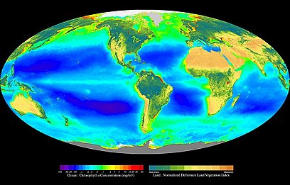
Remote sensing images classify forest cover
Recognizing the importance of forest resources for the process of formation and development of human species has a great role in the protection and protection of the ecological environment. Therefore, using remote sensing photo applications for forest use and exploitation is the best option for the State.
Remote sensing technology reduces the risk
To minimize the risks of deforestation, one of the most effective solutions in many countries in the world today is the application of remote sensing technology to monitor forests.
Aerial photos in remote sensing will classify forest cover, remote sensing images analyze areas of low coverage, manage watershed areas so that the state can have reasonable policies in afforestation, greening bare land, and bare hills.

Remote sensing color combination
Remote sensing image processing services
Using remote sensing images to synthesize and evaluate on cadastral files and on the field about the area, reserves, and quality of forest types at the time of inventory and the situation of changes in forests between two inventories.
Remote sensing image processing process is shown in forest inventory, data, maps…
Remote sensing image survey
Remote sensing application for estimating forest biomass
The application of remote sensing images is in fact the estimation of biomass, in order to support the quick and timely calculation of forest biomass, many countries around the world have conducted research on calculating biomass of Remote sensing-based vegetation such as Landsat, SPOT, AVHRR NOAA, ALOS, …
There are many methods of estimating biomass from satellites through values such as radiation coefficient, reflectivity, and standardized index of different plants (The Normalized Difference Vegetation Index – NDVI), only Number of leaf area (Leaf Area Index – LAI), s-radiation system of photosynthesis (The Fraction of Absorbed Photosynthetically Active Radiation – fAPAR).
Photos taken from remote sensing photo-taking stations have contributed to clarify the theoretical basis from experimental calculations on photos, to propose effective solutions in monitoring vegetation cover. However, in order to calculate the overall biomass of forests, further research is needed in calculating the forest volume as well as the corresponding tree height for each area.
In addition, the number of inadequacies in estimating the forest area created from traditional satellite and forest statistics (due to the problem of forest area identification) should also be addressed from the data supported by GIS.
Aerial photos in remote sensing
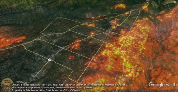
In fact, forest fire warning must use photos from remote sensing
Using remote sensing images in forest protection always sees the importance of this science & technology, from which to analyze images, evaluate the abnormalities on a large scale, to identify areas of drought and cover Low coverage … Warning for forest fires.
cutting remote sensing images by boundaries
Advantages of remote sensing images
Using technology & science, the points selected for verification will be the locations identified on the image, where forest changes, forest growth, or degradation at the time of assessment. The tool used to assess is a topographic map, forest map, growth map layers, forest degradation – results of remote sensing image processing and GPS navigation devices.
Principles of remote sensing images to develop forest information monitoring systems will contribute to improving the state management capacity of forests.
Contributing positively to forest management, early detection of forest degradation phenomena, as a basis for forest management agencies to quickly find out the cause to limit, prevent its harms, contribute to protecting nature and living environment of people more effectively.


