Search and rescue
The search and rescue solution using remote sensing data not only detects and finds objects on the surface of the Earth but also detects the deep geological layers inside the planets.
On Earth, people can use civil aircraft, specialized or artificial satellites to receive remote sensing images. There are two main types of remote sensing: passive remote sensing and active remote sensing.

Remote sensing search and rescue data at sea
A large part of this progress has stemmed from international integration and the contribution of advanced technologies. However, remote sensing imagery plays an important role in marine search and rescue operations today, especially searching for people on board ships, depending mainly on human eye vision.
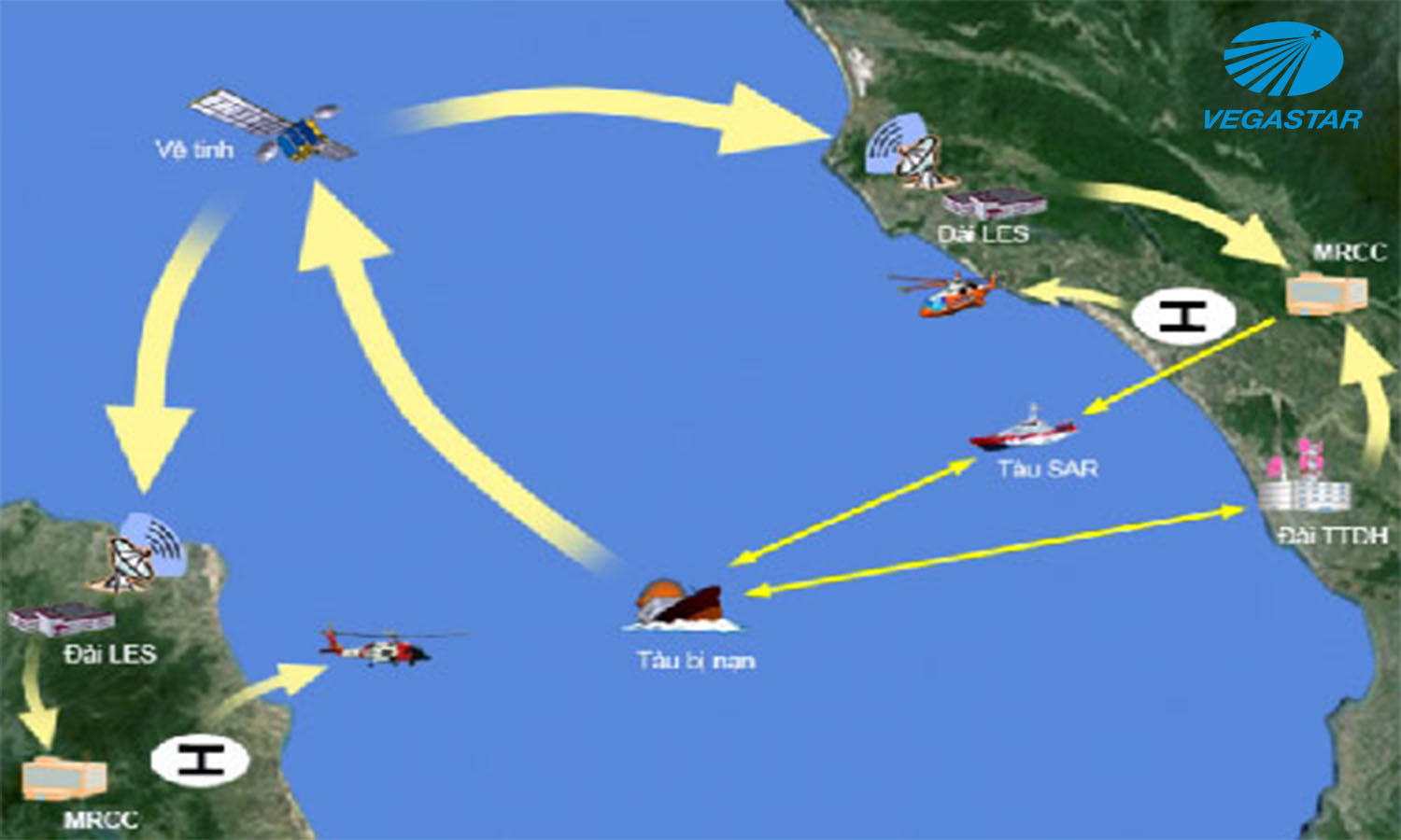
The Safety of Life at Sea (SOLAS) International Convention, which requires ships to be equipped with a global navigation and safety system, has improved search and rescue.
However, for many ships not equipped with global navigation and safety systems, such as fishing boats and small cargo ships, the results were not as expected. With a complex marine environment, finding ships in distress becomes a difficult task.
The limitations of the traditional rescue method
Due to the limitations of the human eye, it is difficult for a rescuer to find a small target in adverse lighting conditions, at night, or in heavy rain or high winds. Long continuous observation also causes eye fatigue, resulting in poor detection sensitivity. All of the above factors have influenced the results of the search and rescue operations.

Using radar satellite remote sensing to identify ships
To improve the efficiency of marine search and rescue operations under adverse lighting and weather conditions, remote sensing technology is a potential method to overcome the limitations of the human eye in search and rescue. marine households, and thus can improve search performance in complex environments or in human fatigue.
In terms of ship surveillance, compared with on-shore, on-board or air detectors, and infrared surveillance methods, synthetic aperture (SAR) satellites are capable of operating at any time and any weather conditions, with wide coverage and high resolution for detecting ships at sea. Especially because the satellite’s operational characteristics are not limited by sea surface, weather, or human factors, it can detect marine areas with remote geographic location and inaccessible environment. continued.
The primary role of geospatial data is to provide a secondary source of information for marine search and rescue operations. To some extent, a remote sensing surveillance system can overcome the shortcomings and shortcomings of the human eye.
It can also improve search speed and accuracy and makes sense in boosting rescue success rates and efficiency. It can assist rescuers in completing search and rescue tasks, especially small targets, such as those in distress, and can provide a good detection and identification result.
Remote sensing imagery allows surveillance remote sensing imaging systems for marine search and rescue consisting of four modules, a surveillance satellite module, a vessel detection module, a state analysis module, and an integrated processing module.
The ship detection module has three functions: locating the ship’s position, identifying/classifying the ship, and predicting the ship’s direction of movement. The sea state analysis mainly estimates the direction of the wave height and current direction.
Based on the results of the position of the ship in distress and the direction of the wave, combined with the time to receive data, it estimates the position of the ship in distress and combines the satellite parameters, it can correct the obtained results over ship detection. Analysis results using the integrated processing module can be transmitted to the Marine Safety Agency and the lifeboat in the field, to make decisions for rescue work.


